News   GLOBAL  |  Apr 02, 2020
 10K     0 
News   GLOBAL  |  Apr 01, 2020
 42K     0 
News   GLOBAL  |  Apr 01, 2020
 5.9K     0 

Caledonia Park Road and Davenport Road Safety Improvements​

Too bad bikeways will not be considered for Caledonia Park Road upon closer review of the slides. Only upgrades to a short block of Davenport. :(
The good news about Eglinton is that the City should be able to design it to add lanes while retaining 4 lanes of traffic to satisfy Ford.. unlike Bloor Street which doesn't have the same road width to work with. I suspect the Eglinton lanes will still eventually make an appearance, just not as soon as we had hoped.
Unfortunately, the parts in between stations would most likely require traffic lane removals.
 
Too bad bikeways will not be considered for Caledonia Park Road upon closer review of the slides. Only upgrades to a short block of Davenport. :(

Unfortunately, the parts in between stations would most likely require traffic lane removals.
The original 2014 study had 4 lanes across the entire corridor minus Avenue-Mount Pleasant.


This is what Metrolinx partially built-out as a part of the Crosstown - the major intersections near stations were done accommodating 4 lanes and bike lanes, and in many cases a turn lane too.

It may cost the city more to keep 4 lanes as they may have to move curbs in some places, which costs $$$, but it's definitely possible. They had a whole preliminary design from a decade ago with it done that way.

The reality is that the City should have found the money in the first place to do a proper rebuild of Eglinton to the full Eglinton connects vision approved in 2014, which includes dedicated cycle tracks, 4 lanes of traffic, upgraded streetscaping, etc.
From what I understood, Eglinton Connects was contingent on redevelopment along the corridor - which could take more than a decade - while eglintonTOday was intended to bring in interim complete street treatments far sooner. While yes the former would have called for keeping all four traffic lanes, the same couldn't be said for eglintonTOday.
 
Eglinton TOday installation deferred. Paving to commence this year. Very disappointing.

Continuing Installation of eglintonTOday​

The remainder of the complete street project from Bicknell Ave (just west of Keele Street) to Mount Pleasant Road will not be installed in 2025 along with the resurfacing of the roadway. The timeline for the installation including areas most impacted by Eglinton Avenue West/Allen Road traffic congestion is still to be determined.

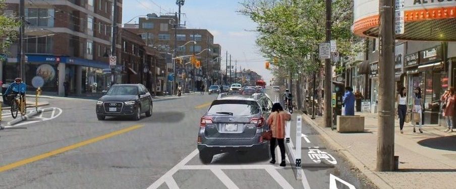
The Davenport segment:

1756300061152.png


1756300100186.png


On this segment, my only 'complaint' is that the parking would be better as streetscaping (tree-lined boulevard).

****

This is the Caledonia Park portion of the project:

1756300278989.png


1756300356816.png


Here, there really isn't room for a cycle track as such. Where this is a planting zone, it is plausible to compress the planting strip to 2.0m, the travel lanes to 3.0m and use the parking lane for a 3.0m Multi-use path, however
that strip isn't available along the entire stretch of road, without it, any MUP would be sub-standard. Even then, squeezing in physical separation would be very tight. The proposed sidewalks are both 0.3m below the City minimum standard.

Take a look at what's being worked with here:

1756300559234.png


In light of that, I'm not unhappy. There's certainly an argument about pushing into the hillside and adding a retaining wall to steal more space... but that's $$$, and I'm not sure its warranted for the gain here.
 
Just put up an action alert regarding Eglinton to hold the City of Toronto accountable and demand they follow through with installation this year.

 
Sign said "Lower Don Trail" project, but since I can't seem to find a thread for that, I hope this'll suffice - new bike ramp to the trail exit near 701 Don Mills Road:
View attachment 677197View attachment 677198View attachment 677200
I know there's another thread with some of this. Anyway, I cycled southbound from TE Seaton park yesterday, so I came up to this intersection from under Don Mills (i.e. from the left in the first photo, and the right in the second). The mirror they have installed gives a good view of traffic coming down the new path and from over the bridge.
 
Track on Esplanade south side just west of Market St. earlier today, only for only ~half a block. There didn't seem to be anything else being constructed west of Jarvis along Esplanade other than this little bit (although I didn't walk all the way over to Yonge). Anybody know what the status / timeline is of the Jarvis to Yonge section? City website said complete Market-Yonge section would be complete by June 30, but I could just be missing an update somewhere

IMG_20250829_113511.jpg
 
I was cycling on BAYVIEW today and it LOOKS as though the steel they have been waiting for to build the stairs/ramp from Dundas to the Lower Don Trail has arrived. Large trailer with steel parked on the trail. Could they actually be working on finishing off this work???
 
Track on Esplanade south side just west of Market St. earlier today, only for only ~half a block. There didn't seem to be anything else being constructed west of Jarvis along Esplanade other than this little bit (although I didn't walk all the way over to Yonge). Anybody know what the status / timeline is of the Jarvis to Yonge section? City website said complete Market-Yonge section would be complete by June 30, but I could just be missing an update somewhere

View attachment 677417
Just walked by there and noticed covered signage and groups of pylons. If they get it done this weekend, they’ll make their “done by the end of August” promise!

IMG_6629.jpeg
IMG_6630.jpeg
IMG_6632.jpeg
 
Track on Esplanade south side just west of Market St. earlier today, only for only ~half a block. There didn't seem to be anything else being constructed west of Jarvis along Esplanade other than this little bit (although I didn't walk all the way over to Yonge). Anybody know what the status / timeline is of the Jarvis to Yonge section? City website said complete Market-Yonge section would be complete by June 30, but I could just be missing an update somewhere

View attachment 677417
This tiny section was started in early summer and took months to get to this point. There is lots of discussion above but the consensus seems to be that they will do nothing more this year and next year they MAY get to Scott. Though the Cycling team are normally very good, this has NOT gone well and was partly held up because they did not get the necessary parking changes to Council ages ago. They were finally passed in July and, though someone from Cycling told me they hoped to get it done by end of August here we are and nothing has changed. NOT GOOD! https://secure.toronto.ca/council/agenda-item.do?item=2025.IE23.6
 
Just walked by there and noticed covered signage and groups of pylons. If they get it done this weekend, they’ll make their “done by the end of August” promise!

View attachment 677435View attachment 677436View attachment 677437
The (bagged) signage is new but the orange barrels have been on The Esplanade since about April. If they are actually going to 'do something' there are several areas of very rough pavement and utility cuts on The Esplanade between Scott and Church that they need to re-pave.

EDIT: Just looked more closely at the bagged signage. They appear to be making The Esplanade one-way westbound between Scott and Church though I do not remember seeing any notification of this getting approval at TEYCC or Council.. Hmmmmmm

This is what is in the Mill - Esplanade Plan and I assume it was approved with the whole plan. https://www.toronto.ca/community-pe...structure-projects/the-esplanade-mill-street/

1756571837825.png


The TOInView site notes that they have plans and $$ to resurface The Esplanade between Scott and Church in 2025 (planned since 2022!)

1756572517154.png
 
Last edited:
Steeles Ave East @ Walkway to Enchanted Hills Cres
View attachment 677556
Steeles Ave & McCowan Rd
View attachment 677557

It would be smart if transportation services took the budget allocated for quick-build projects unable to move forward due to Bill 212 for at least the next few years and instead just focused on building nice cycle tracks like these and beautified existing ones instead.
 

Back
Top