


Albertasaurus
Senior Member
DP has been submitted for "Onward Shaganappi", across Bow Trail from the Crown Park abomination. Architect is C1ZN, developer Onward Homes. If the render is to be believed, passenger rail coming to Bow Trail soon ")


|
|
|
This is where my mind went, too. But I think we really should make perfect the enemy of good/better here - it's really important and they'll be reluctant to tear it up again.Could this open the door to bus lanes on some of those downtown corridors? We don't need to blow our brains out on these, all i really want is a bus lane and a consistent curb and experience from end to end.
CoC has never heard of this in the suburbs, could you explain?There's potential to improve pedestrian and cyclist infrastructure and to add some traffic calming measures.
It COULD.... I mean, anything is possible, right? But, like Calgouver said, the City probably won't... I hate to be cynical about it, but literal decades of experience in this has me siding with Calgouver on this.Could this open the door to bus lanes on some of those downtown corridors? We don't need to blow our brains out on these, all i really want is a bus lane and a consistent curb and experience from end to end.
I grew up mostly in Canyon Meadows. The massive berm on the east side was to satisfy Bonavista NIMBYs. It went up Sep-Oct 1987. The original plan had a direct road connection into Bonavista that was also blocked by NIMBYs. Avendia was originally an upscale, Spanish themed mall targeted at wealthy Bonavista residents.Biggest thing I know from experience on Lake Fraser Drive from 20 years ago walking to the Canyon Meadows lrt is the crosswalk from Bonavista is deadly. Every other week there were signs advising pedestrians of accidents with motorists. There's also a massive grass set back on the Bonavista side that I've never understood. There's potential to improve pedestrian and cyclist infrastructure and to add some traffic calming measures.
I maybe am mis-remembering, but wasn't there a relatively recent functional study as part of Green Line / Max Green that sketched out a plan on how bus circulations are supposed to work downtown with dedicated bus lanes? Perhaps that can be dusted off for some of these major avenues?It COULD.... I mean, anything is possible, right? But, like Calgouver said, the City probably won't... I hate to be cynical about it, but literal decades of experience in this has me siding with Calgouver on this.
I have a feeling we will see cracked sidewalks replaced as is, and a milling down of the asphalt and a new lift installed. No change to the design, just a rehab of the existing.
I grew up mostly in Canyon Meadows. The massive berm on the east side was to satisfy Bonavista NIMBYs. It went up Sep-Oct 1987. The original plan had a direct road connection into Bonavista that was also blocked by NIMBYs. Avendia was originally an upscale, Spanish themed mall targeted at wealthy Bonavista residents.
I used to ride dirt bikes on that site and don't remember any drainage problems. The strip mall, Holiday Inn, residential complexes and car dealerships to the north of Avenida was the Chateau Estates trailer park. Ave Ida and the parcels to the south were the originally proposed site for the south Calgary hospital. Plans changed and the land was sold. Avendia opened Spring of 1988. The smaller mall with the Arby's opened Summer 1990. The large Food City grocery store, now the movie theatre opened Summer 1993. The newer houses along Bonaventure Drive were built 1993 to 1994. The Nutrien office building opened in 2000. The funeral home and car dealership oepend in 2001 a few months ahead of the LRT station.
I wonder if a major redevelopment proposal is coming if Lake Fraser is being improved?
You can even get Council approval to do something, but apparently, still have it die on the vine. Anyone else remember the bus only lanes that were supposed to happen on 4th Street?I maybe am mis-remembering, but wasn't there a relatively recent functional study as part of Green Line / Max Green that sketched out a plan on how bus circulations are supposed to work downtown with dedicated bus lanes? Perhaps that can be dusted off for some of these major avenues?
I always will find it bizarre that for many major roads, there's an apparent status quo bias so strong that it almost seems to snuff out plans or concepts before they can even be designed. Then the lack of a new concept plan or functional study is used as the reason we can't do anything different (because lots of actors actively resisted doing a new plan in the first place)
 calgaryherald.com
Great example - it goes all the way to Council, has a bunch of concepts and things figured out about it, gets approved, and then..... nothing. You'd think there'd be a feedback loop somehow a few years later that says "hey look, we aren't going to do this anymore because of X, Y or Z reasons". It's only through informal, murky channels is the project alive or dead downtown, official and public channels don't seem to have the right information.You can even get Council approval to do something, but apparently, still have it die on the vine. Anyone else remember the bus only lanes that were supposed to happen on 4th Street?
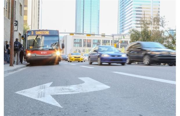
.Council OK’s transit-only lane on 4th Street S.W.
Bus commuters on Route 3 out of downtown will get to breeze by congested car traffic in the coming years, thanks to the planned installation of a transit-only lane on 4th Street S.W. City council approved the idea earlier this year, and the lane — or lanes — will likely be installed between 4th...
I had school friends that lived in the trailer park. I went to St Catherines elementary when it was the most southerly elementary in the city so it had a large catchment area.I actually worked at the Canyon Meadows theatre in Junior High in the mid 90's. Didn't realize the Nutrien building has been there so long, but then I was taking the lrt to highschool in 2000 and do recall seeing it under construction. I remember the trailer park as well. Damn, I must be getting old.
I half suspect that queue jump was removed because the Suncor Centre renovations requested to have that outside land closed as part of their construction site. Because the group within Roads Operations who grants these closure permits doesn't interact with transit planning, the request was granted. It doesn't matter that the time and cost savings for the busiest bus route in the city were impacted. You would think there would be a senior official, let's call that position I don't know, the GM of Operations, that would be on top of stuff like this....Great example - it goes all the way to Council, has a bunch of concepts and things figured out about it, gets approved, and then..... nothing. You'd think there'd be a feedback loop somehow a few years later that says "hey look, we aren't going to do this anymore because of X, Y or Z reasons". It's only through informal, murky channels is the project alive or dead downtown, official and public channels don't seem to have the right information.
All sorts of small and big stuff pops up and goes away, usually without fanfare or much reporting. I recall a nice queue jump signal installed during the pandemic (quietly) to access Centre Street from 5th Ave, then it was removed later (again quietly). Saved each centre street commuter a minute or two for a couple years then removed silently with no plan, strategy or communication readily available.
Find me a government that's notthe City really is a terribly run organization.....

They still do janky curb lines on brand new development in areas under the public realm setbacks table. Lo and behold: https://www.google.com/maps/place/Calgary,+AB/@51.0489479,-114.0840423,3a,34.3y,259.31h,81.57t/data=!3m7!1e1!3m5!1srzGfzThogDWybTMUff2trA!2e0!6shttps://streetviewpixels-pa.googleapis.com/v1/thumbnail?cb_client=maps_sv.tactile&w=900&h=600&pitch=8.433289602121263&panoid=rzGfzThogDWybTMUff2trA&yaw=259.311310338902!7i16384!8i8192!4m6!3m5!1s0x537170039f843fd5:0x266d3bb1b652b63a!8m2!3d51.0447331!4d-114.0718831!16zL20vMDFyMzI?entry=ttu&g_ep=EgoyMDI2MDMwOS4wIKXMDSoASAFQAw==I guess this thread is as good of a place as any to post this. As part of the massive capital spend that Administration is proposing to Council over the next decade, some details are starting to come out, and will be at tomorrow's Infrastructure and Planning Committee. Specifically item 7.9
Within that item on the agenda you can see attachments for the various infrastructure types, with what is proposed in this list (although I don't think it is comprehensive). The one that stood out to me as having some potential is as follows, found in the Roads and Pathways 10-year Capital Infrastructure Needs Assessment.
View attachment 720903
That is a good list, with a lot of downtown avenues and even 9th Ave through Inglewood. I don't expect all of them to get the full Stephen Ave treatment (for instance the main commuter aves downtown like 4/5/6/11 listed), but I sure do hope they at least come up with a proper design that incorporates corner bulbs, clearly defined parking lanes, tree alignments, and most of all, gets rid of these stupid janky curb lines. Maybe they will even deal with the public realm setbacks in the land use bylaw when they do these corridors. Probably not, but a man can hope!