News   GLOBAL  |  Apr 02, 2020
 11K     0 
News   GLOBAL  |  Apr 01, 2020
 43K     0 
News   GLOBAL  |  Apr 01, 2020
 6.8K     0 
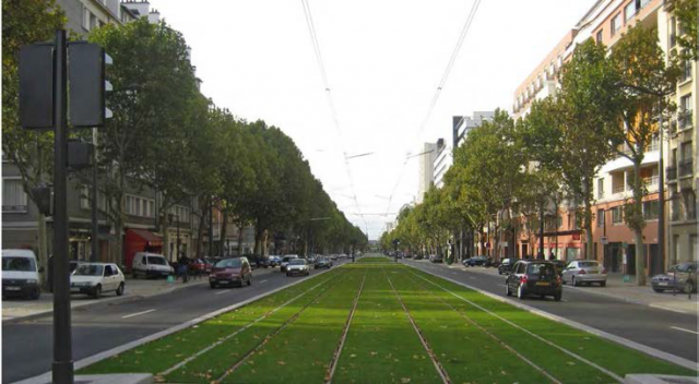
It might not even be grass. It could be sedum. (Like the green roof at Eglinton West station.)
 
data=!3m6!1e1!3m4!1sz-h9pfwjM9kkfslLewMEVA!2e0!7i13312!8i6656


https://www.google.ca/maps/@43.5946...h9pfwjM9kkfslLewMEVA!2e0!7i13312!8i6656?hl=en
City Centre Station on the Missisauga Transitway. a small, ~3 foot wide enclosed shelter. its literally the width of a door. why is this design not being use here. This small detail has the ability to completely change peoples perception of the project. If budget was an issue, i would say axe the green track and use the shelters.

In the photo of the crosstown example stop. It could literally fit in between the back of the platform and the black texture line on the platform. preservering accessiblity needs with sufficient space for a wheelchair or stroller moving in front. To minimize flow impacts, place it near the end of the station platform where the traffic flow of peds would be minimal.

Edit: photo won't load but click through the link.
 
Last edited:
A green trackway?
17765-59433.png


Oh, oh! The NIMBYs from St. Clair Avenue West & Queen's Quay and the city Transportation Department will have none of this. Having grass or organics will only improve the look of the right-of-way, and we can't have that in Toronto. Drivers may even avoid driving on the right-of-way. (Sarcastic.)
 
And of course it has "bike lanes" (very similar to the ones on the Highway 7 busway which absolutely no one every uses) which are unsafe and ought to be removed from the design.
 
It works only if its all crab grass. Patches here and there indicate neglect and poor maintenance

So. Turns out University of Minnesota has been doing research on road-side grass. Crabgrass works fine, but is invasive in many areas so not preferred.

What they ended up with was:

"40% total of a combination of hard, Chewings, and sheep fescue (several cultivar options), 20% slender creeping red fescue (3 cultivar choices), 20% strong creeping red fescue (5 cultivar choices) and 20% Kentucky bluegrass (4 cultivar choices)."

Some adjustments were made since then.

Pic-3-Gov-1024x576.jpg
 
Last edited:
I have a feeling that a lot of you will be happy with the at-grade station designs: http://urbantoronto.ca/news/2015/10/previewing-crosstowns-green-trackway-and-grade-amenities

This article today and from last week prompted me to revisit the UT database entries for the underground stations. For the most part I like what I see and look forward to seeing more detailed renderings. However there are a couple of things that annoy me.

First of all, the stations are really deep underground. It's sad that cut and cover subway construction will never happen again in this city, because the downtown Yonge stations are so much more compact and easier to use than newer ones such as Don Mills. Some of the older stations even have their fare gates at street level, so after you pay the fare then you just walk down a short flight of stairs to get to the platform. Meanwhile, lets compare that to just one of the crosstown stations:

Screen shot 2015-10-05 at 8.43.58 PM.png


Screen shot 2015-10-05 at 8.44.15 PM.png


Screen shot 2015-10-05 at 9.48.13 PM.png


Screen shot 2015-10-05 at 8.43.40 PM.png


There are literally enough stairs here to climb a highrise building. Not only that, but I see a serious efficiency flaw in the above photo where the GO station is. When you get off the GO train, you can't go directly downstairs from the platform. Instead you have to go up all the way to street level, and then go downstairs again to get to the LRT:
Screen shot 2015-10-05 at 9.48.41 PM.png

I thought Sheppard-Yonge station was inefficient, but this one takes abysmal circulation to new heights thanks to the hundreds of stairs.


And finally, the traffic island located next to the bus loop will be retained according to this pic:
Screen shot 2015-10-05 at 8.42.49 PM.png


Here's a streetview pic of what it looks like. Obviously it's an ugly, unnecessary relic of the car era. I assume that this will be removed when the Eglinton Connects streetscape improvements are implemented, because I refuse to believe that this thing will somehow survive despite all the money being spent to improve Eglinton. For now I'm not gonna worry about it too much.

Screen shot 2015-10-05 at 10.11.10 PM.png
 

Attachments

  • Screen shot 2015-10-05 at 8.43.58 PM.png
    Screen shot 2015-10-05 at 8.43.58 PM.png
    476.1 KB · Views: 673
  • Screen shot 2015-10-05 at 8.44.15 PM.png
    Screen shot 2015-10-05 at 8.44.15 PM.png
    503.5 KB · Views: 666
  • Screen shot 2015-10-05 at 8.43.40 PM.png
    Screen shot 2015-10-05 at 8.43.40 PM.png
    423.5 KB · Views: 657
  • Screen shot 2015-10-05 at 9.48.13 PM.png
    Screen shot 2015-10-05 at 9.48.13 PM.png
    274.7 KB · Views: 654
  • Screen shot 2015-10-05 at 9.48.41 PM.png
    Screen shot 2015-10-05 at 9.48.41 PM.png
    571.2 KB · Views: 646
  • Screen shot 2015-10-05 at 10.11.10 PM.png
    Screen shot 2015-10-05 at 10.11.10 PM.png
    1.3 MB · Views: 772
  • Screen shot 2015-10-05 at 8.42.49 PM.png
    Screen shot 2015-10-05 at 8.42.49 PM.png
    463.1 KB · Views: 761
Last edited:
Most newer subway systems around the world have deep stations with machine-bored tunnels (eg. Montreal has some insanely deep ones). I personally don't think it's that bad with escalators.

However it's also that Eglinton itself is pretty hilly in places. Also this line has to go underneath the current subway lines and be constructed while line 1 is operational.
 
The Rogers Centre is getting rid of its artificial turf. It can perhaps be reused for the Eglinton Crosstown LRT.
 
Salsa - apparently you've never been on the Tube in London. Many stations are 20m to 30m down (seven to ten storeys). The deepest station is Hampstead at 58m (20 storeys). There are three reasons for this: One, there are hills and railways can only go up certain grades; Two, many lines have to go under the river Thames, which deep (capable of docking warships); and Three, there is a layer of easily mined but strong rock (I don't recall if its chalk or sandstone or something else) that makes construction easy at that level.
 
Cut and cover worked for the Bloor line - sort of. There were some pretty buildings demolished in those pre-preservation days, and land prices were in a different league than today. Arguably those back-alley parking lots that emerged along the Bloor line after the construction were an enhancement that has served the city well. I'm not so sure one could make the same case for the lines we are building today.

It's true that other cities do well with deep tunnels. The key is they have put in sufficient elevator and escalator capacity, and those devices are maintained to a high standard. An elevator outage is an urgent matter. TTC will have to up its game to follow suit. It can be done, it just takes the right mindset.

- Paul
 
Salsa - apparently you've never been on the Tube in London. Many stations are 20m to 30m down (seven to ten storeys). The deepest station is Hampstead at 58m (20 storeys). There are three reasons for this: One, there are hills and railways can only go up certain grades; Two, many lines have to go under the river Thames, which deep (capable of docking warships); and Three, there is a layer of easily mined but strong rock (I don't recall if its chalk or sandstone or something else) that makes construction easy at that level.

Correct, they do have some bloody deep stations and long escalators. The layer they've bored through isn't rock however, but a clay seam - which in many ways is better than rock. Easy to mine, under pressure, and extremely impermeable. The layer however changes depth south of the Thames, which is a reason their Tube hasn't extended as far south of there.

Worth noting to those that don't know, but London also uses two types of rolling stock: Subsurface and Deep Tube trains. Also that 55% of their Tube is actually on the surface.
320px-London_Underground_subsurface_and_tube_trains.jpg
 
And finally, the traffic island located next to the bus loop will be retained according to this pic:
View attachment 56455

Here's a streetview pic of what it looks like. Obviously it's an ugly, unnecessary relic of the car era. I assume that this will be removed when the Eglinton Connects streetscape improvements are implemented, because I refuse to believe that this thing will somehow survive despite all the money being spent to improve Eglinton. For now I'm not gonna worry about it too much.

The right hand turn onto the side street is greater than 90 degrees. So it will require either a right turn lane or an island (otherwise turning traffic will have to slow down so much it will create a dangerous situation. It also makes an effective "kiss and ride" drop off location.
 

Back
Top