News   GLOBAL  |  Apr 02, 2020
 10K     0 
News   GLOBAL  |  Apr 01, 2020
 42K     0 
News   GLOBAL  |  Apr 01, 2020
 5.9K     0 

yes, retains 4 lanes but only in peak periods and only between Oakwood and Spadina.

The original Eglinton Connects plan had it as 4 lanes across the entire corridor other than between Avenue and Yonge. There are multiple intersections built out by Metrolinx for 4 lanes that the City is currently planning to "downsize" to 2 lanes, including Avenue Rd, Dufferin St, Keele St, etc.
How do you lose lanes off peak?
 
How do you lose lanes off peak?
Parking.
8b56-eglintontoday-cross-section-C-oakwood-bathurst.jpg
 
By way of the Lobbyist Registry, some future cycling infra being discussed:

1739212668317.png
 
A few shots / updates from a ride yesterday along the Rosedale Valley Road MUP and the Bayview bike/pedestrian path.

Below: The RVR MUP is plowed, but narrowly. I passed a couple of walkers and it was far too narrow for a safe pass. Would be worse with opposite direction cyclists. I'm not certain how many passes the plows do, but I'm guessing two? I think with those narrow buckets they use for these trails, a third pass would be warranted – but that would probably mean four, assuming they need to return to a truck that is sitting at one end of the trail.

PXL_20250210_175823522.jpg


In good news, the protective scaffolding has been removed from the trail under the "new" pedestrian bridge that is now in its third year of construction (below). Ironically, they had a crane crew working directly above the trail here, so I had to shout for them to not drop anything on me. Not sure my bike helmet is rated for 75-foot hammer drops. In any case, it's hopefully a sign that the bridge is nearer to completion than a few weeks back when the protection was still in place.

PXL_20250210_210504092.jpg


Coming off the RVR path, southbound cyclists are obliged to (legally) proceed along the west-side trail on Bayview, if they want to access River Street further south. This is the weird arrangement with the one-way bike lane and a bidirectional footpath separated by a dotted line. I always stare at the paint logos in bewilderment. To my surprise the trail was blocked under the Riverdale Viaduct, by several cones and a large construction vehicle. As you can see there is no safe passage for a cyclist here, and I had to skirt the road-side of the bollards with fast-moving traffic. A worker told me the closure would only be a day or two, but this is one of the many occurrences I run into each day that show the city has not gotten serious about improving construction site safety for cyclists, pedestrians and people with disabilities. Thism, despite assurances there were doing so a few years ago.

PXL_20250210_180110574.jpg


On the plus side, this work indicates that promised upgrades to the Riverdale Viaduct -- which ties into the Lower Don Trail improvements -- are proceeding.

You take the good, you take the bad, you take 'em both and there you have: cycling in Toronto.
 
Can you share any context? I admit I have no idea what this means. I cannot find any online information about the UTSC Bike Lanes Workshop. Someone wants to lobby for/against it?

Here's what's public.......

1739502516319.png


Its from last year's June report (so June 2024), on the Cycling Plan 2025-2027


Best I can do.....
 
Here's what's public.......

View attachment 631159

Its from last year's June report (so June 2024), on the Cycling Plan 2025-2027


Best I can do.....

Here's what's public.......

View attachment 631159

Its from last year's June report (so June 2024), on the Cycling Plan 2025-2027


Best I can do.....
Thanks for trying!

Not sure what the "workshop" refers to, that sounds like a class or a structurs. And are the lobbyists looking to support these lanes or oppose them?
 
Here's what's public.......

View attachment 631159

Its from last year's June report (so June 2024), on the Cycling Plan 2025-2027


Best I can do.....

Screenshot_20250213-224252~4.png


So I did some Googling, and it looks like at some point the plan is to realign Military Trail, I guess if and when the LRT is ever built. I am guessing at some point the plan was to have some sort of bike infrastructure along the new alignment of Military Trail (blue) but the discussion is now to have this along the old alignment instead (purple).

edit: green NOT purple, not sure how I got the two confused lol
 
Last edited:
View attachment 631160


So I did some Googling, and it looks like at some point the plan is to realign Military Trail

That remains the plan, and is not contingent on the LRT, though the projects may overlap in time (or not)

. I am guessing at some point the plan was to have some sort of bike infrastructure along the new alignment of Military Trail (blue) but the discussion is now to have them along the old alignment instead (purple).

That sounds plausible to me.
 
You're welcome.


I think what is being opposed/sought can be inferred from the motion.

****

Can't say more than that for now.
You're welcome.


I think what is being opposed/sought can be inferred from the motion.

****

Can't say more than that for now.
View attachment 631160


So I did some Googling, and it looks like at some point the plan is to realign Military Trail, I guess if and when the LRT is ever built. I am guessing at some point the plan was to have some sort of bike infrastructure along the new alignment of Military Trail (blue) but the discussion is now to have this along the old alignment instead (purple).

edit: green NOT purple, not sure how I got the two confused lol
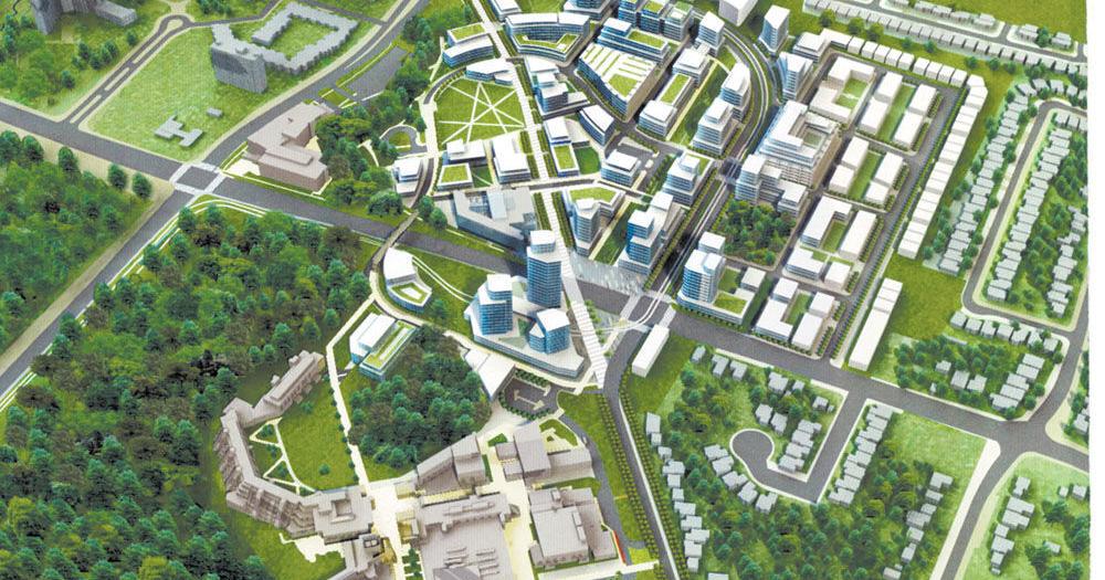
Where is this very interesting 3D map from? Apple? Or is this an arch. rendering?

Edit: I found it (thanks reverse image search) and there is a lot more info and context for those who actually want to know, about the UTSC's Master Plan, which involves a bit about cycling plans. Though it seems like at least earlier they were just aiming for "shared" roadways, which to me just means, "roadways."


Sounds like if I'm inferring correctly, there is a move to upgrade that to actual cycling infra. And U of T is, perhaps, lobbying for that.
 
Last edited:
The first of two, pre-summer Cycling Infrastructure updates is headed to the next meeting of Infrastructure and Environment Ctte:


The notable projects are Bathurst, and a portion of Ellesmere. Though a few smaller initiatives are also included.

From the above:

1740062915125.png

1740062941313.png

The Eglinton-Allen intersection gets its own mention:

1740063012298.png


Project Map:

1740063300286.png


1740063328702.png
 

Back
Top