DSCToronto
Superstar
Yes, the site of Berkeley House was excavated when the Globe & Mail building was built. There are probably posts on it on that OLD UT thread. I think the consensus was that the last photo in your series shows the house at the very east end of the G&M building adjacent to the heritage building that is still there on King @ Berkeley.Berkeley House:
1802:
View attachment 675304
1885:
View attachment 675314
View attachment 675320
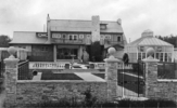
1908:
View attachment 675325
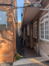
A google search produced a (no longer available) Reddit Thread " Foundations for the "Berkeley House" unearthed during construction of The Globe and Mail Centre." with only this photo (2013)
Last edited: