Sauga89

Active Member
Member Bio
Joined
Oct 30, 2024
Messages
582
Reaction score
1,621
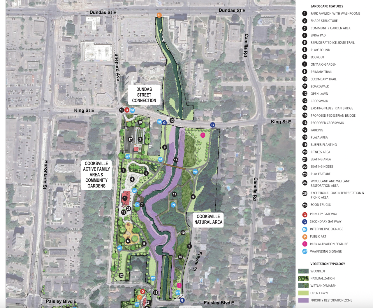
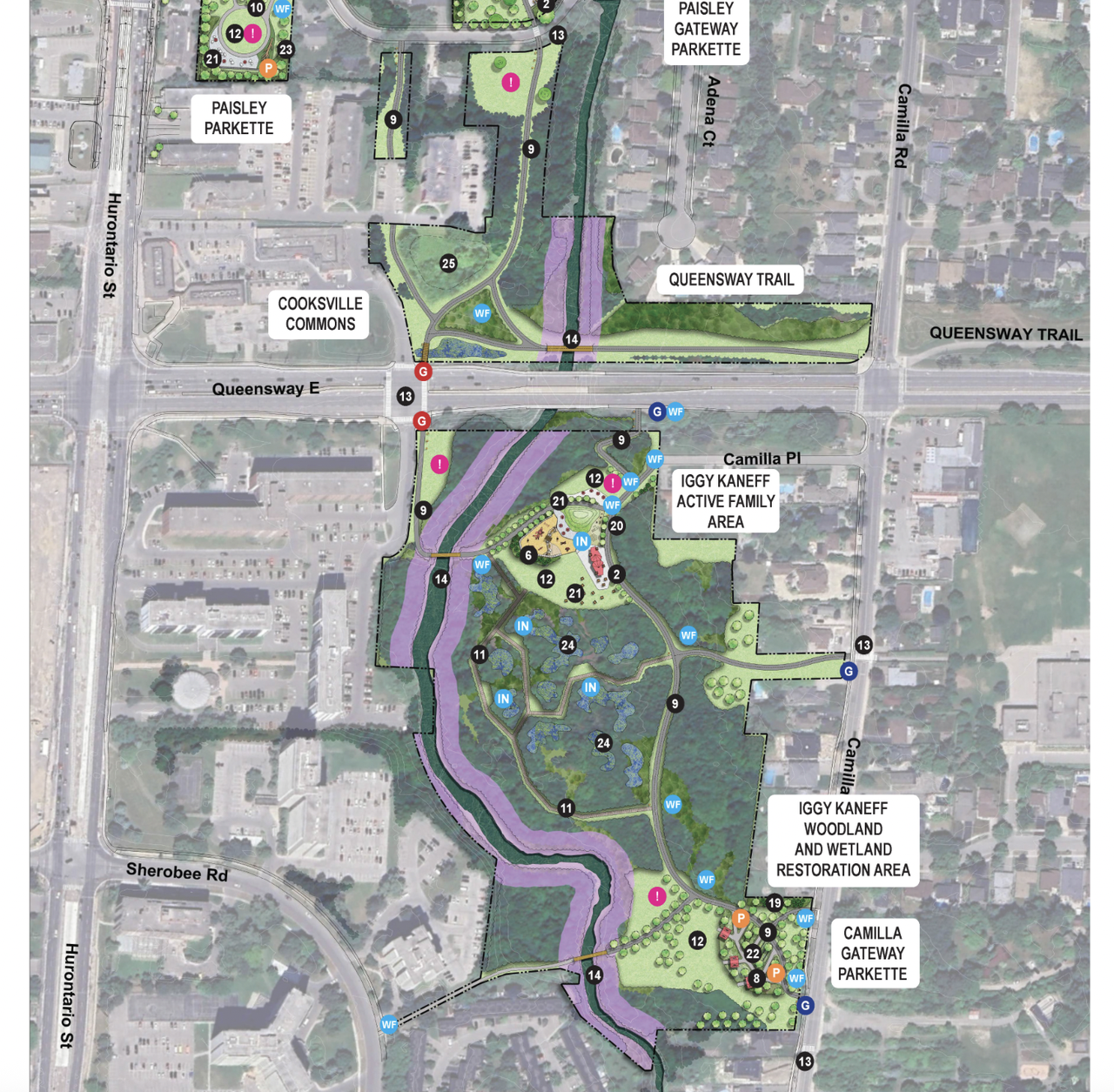
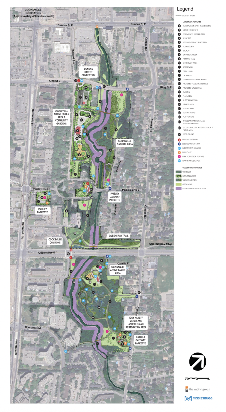
Mississauga has revealed a detailed concept for its new and expanded Cooksville Park. Here is the link to the survey on the project. The survey deadline is May 31. The park design is by The MBTW Group. Construction is expected in 2027.
Screenshot 2026-05-12 at 6.01.27 AM.png

Screenshot 2026-05-12 at 6.03.17 AM.png


Screenshot 2026-05-12 at 6.04.34 AM.png


Also, I see that the city has started the procurement process for the demolition of 5 more homes to make way for the park.

(Note to mods: this park project has previously been discussed in the general Cooksville thread, but I felt the detailed park vision merited its own thread. Feel free to merge as needed.)
 
Excellent post @Sauga89 !

As one might imagine, my sympathies lie with the naturalization/restoration components more than the others. So the Kaneff Woodlot section is the star of the show here for me.

I don't object to the recreational aspects, but I'd prefer they kept entirely above the slopes, which should also have, at the very least a 10M natural buffer.

From just north of Paisley to the Queensway in the south, the creek remains very rigidly channelized. Aside from being unnatural, this is unwise as it will tend to speed up flow rate of the water and increase erosion risks downstream.

I'd really like to see Mississauga acquire the homes on Frayne and Adena that back on to (or front) the park/creek and add them to the natural area. This would probably cost in the range of 30-40M for purchase, and another 15M for demolition/restoration.
 
I'd really like to see Mississauga acquire the homes on Frayne and Adena that back on to (or front) the park/creek and add them to the natural area. This would probably cost in the range of 30-40M for purchase, and another 15M for demolition/restoration.
It's not clear from the first map, but I believe that part of the creek is already in public hands. The Credit Valley Conservation Authority owns two lots here, but they haven't been incorporated into the park design.

The blue shaded lots below belong to the conservation authority.
Screenshot 2026-05-12 at 7.14.43 AM.png


If the city were to acquire more property, I would prefer it be either on the south end, to form a better connection with the Nine Creeks Trail, or the north end, to connect it to the trail north of Dundas. Most of Cooksville Creek between the lake and the city centre is already public owned, should the city ever desire a connection.

I'm also a little nervous that the remaining houses on the west side of Shepard will prevent density being added along the Hurontario corridor.

Overall though, I think it's a great park design.
 
It's not clear from the first map, but I believe that part of the creek is already in public hands. The Credit Valley Conservation Authority owns two lots here, but they haven't been incorporated into the park design.

The blue shaded lots below belong to the conservation authority.

To give natural drift to the creek, letting it meander a bit, requires about 20M more land in the pinch points than they have now.

If you want the natural areas of the park to be successful for wildlife, there needs to continuous green corridor but also a forested sections, as most wildlife doesn't want to move in the open, a 30m wide forested area is pretty much a minimum .

If the city were to acquire more property, I would prefer it be either on the south end, to form a better connection with the Nine Creeks Trail, or the north end, to connect it to the trail north of Dundas. Most of Cooksville Creek between the lake and the city centre is already public owned, should the city ever desire a connection.

I'm all for that too.

I'm also a little nervous that the remaining houses on the west side of Shepard will prevent density being added along the Hurontario corridor.

The lots on Hurontario are over 80m deep, they will easily support towers (you need 40m'ish). but removing the homes on Shepard would allow for more/better development and/or an enlarged park or both, particularly, by shifting Shepard to the west slightly and adding that to the park.

The full lot dept Shepard to Hurontario is ~150m, 100m would be sufficient to provide for towers and midrise interlaced and you could add 50m to the park continuously.

Now if the City were smart, it could buy up the block, upzone it, then resell the portion up against Hurontario for a healthy profit which would pay a large portion of the cost.

Overall though, I think it's a great park design.

Agreed. Though, the devil is in the details. From plant selection to to the quality of washroom and playground design. The community should insist on design being done well
 
Last edited:
I would love it if, once the southeast corner of Dundas and Hurontario are redeveloped, a chunk of the existing parking lot is added to this park. Same goes for the short stretch of the creek underneath a parking lot on the north side of Dundas. Having an impressive green frontage on Dundas itself, close to 5&10, the LRT, and the BRT would go some ways towards making this park feel like a featured part of the fabric of this area.
 
Not sure why the city map isn't updated, but I highlighted the in green a couple lots that they already own, and in blue I highlighted the CVC sections. I highlighted in yellow the homes on Adena Court because I agree they should get acquired, as well as a few other properties which I think they should acquire.

I think they should close one of the legs of Paisley and just make the remaining leg two-way. I don't really get why it was built that way but it seems unnecessary and they could make the park more continuous that way.

Screenshot 2026-06-06 at 4.34.25 PM.png
 
Not sure why the city map isn't updated, but I highlighted the in green a couple lots that they already own, and in blue I highlighted the CVC sections. I highlighted in yellow the homes on Adena Court because I agree they should get acquired, as well as a few other properties which I think they should acquire.

I think they should close one of the legs of Paisley and just make the remaining leg two-way. I don't really get why it was built that way but it seems unnecessary and they could make the park more continuous that way.

View attachment 742232

Councillor Damerla showed this map below during a council meeting last week (2:02:10 minute mark). It shows 4 properties the city has recently acquired. The city issued a procurement notice for 5 demolitions, so I assume the fifth demolition is for a different park. The city has previously added a couple properties to nearby Hancock Woodlands park, and grouped those demolitions with the Cooksville Park demolitions.

Screenshot 2026-06-06 at 5.40.34 PM.png


Councillor Damerla noted that she was excited that the city had acquired the lot near the corner of Paisley and Hurontario, so that the park would have an access point from Hurontario. However, I disagree. That lot is pre-zoned for up to 25 storeys (or 35 storeys if it doesn't conflict with the hospital helipad flight path). Before Damerla made her comments, I half-assumed the city was planning a land swap. If you traded the lot on Paisley for the easternmost block of the Park Towers apartments, you could have a more contiguous park and add density. The easternmost Park Towers block is deep in the flood zone, surrounded by parkland, and only zoned up to 8 storeys. Residents of that 5-storey block could move into a new taller building facing Paisley. Ideally, driveway access for such a development could be from Queensway, and you could make a forested multi-use trail to connect to Hurontario in the way Damerla wants.

Also, I found the Credit Valley Conservation Authority's floodplain map tool.

Screenshot 2026-06-06 at 6.14.07 PM.png
 

Back
Top